Other Monuments of Old Djulfa City
As an important commercial center, Djulfa became notable for its many medieval architectural monuments in the middle ages.
Among them were its splendid bridge, mighty fortress, impressive monastery, eight handsome stone-built churches, numerous caravanserai and trade centers, the covered market, resplendent mansions, its ram-shaped tombstones, and perhaps most of all for its many thousands of intricately carved Armenian memorial stelae called khatchkars, which for centuries stood upright in Djulfa’s cemetery and near its churches.
The Monastery of Amenaprkich (The Holy Redeemer)
The Amenaprkich Monastery complex consisted of a small church, a gavit, a refectory, one and two-storied annexes, and other auxiliary structures enclosed within a rampart. According to M. Smbatiants, the Monastery was founded in 1271 by a “paron” (sir or Mr. in Armenian derived from the French “baron”) Vahram. However, written sources indicate that this monastery was, in fact, older than 1271. The Catholicos Khatchik testified in a document that in 976, King Ashot of
The strong high walls enclosing the rectangular monastery complex are still intact at a height of 2.5 meters. They are built of a rubble-stone and limestone mixture and give the impression of a fortress-rampart whose small and only entrance is on the southern façade.
The monastery has its own small cemetery – not the famous cemetery – where the ashes of monks and bishops are interred. Khatchkars with remarkable reliefs were erected for these individuals, most of which have been dated to the 15th-16th centuries).
Among the ravines of the “Kamu” gorge and the mountains near Jugha there are a number of crevices, natural caves, and caverns of which the more well-known are the “Jgnavor” (hermit), and the “Krekatjatun” (place where lime was produced). They are located north of the Amenaprkich Monastery in the “Kamu” gorge.
During the II-I millennia B.C., these caverns were used for shelter, while in the period preceeding the “great deportation” from Djulfa they were secure hiding-places. The cave “Krekatjatun” was also used in the Middle-Ages as a workshop to prepare lime, from which it received its name.
Public
This monument was situated between the town cemetery, and the area near the
The bath was probably built in the 16th century, since it is traditionally connected with Khoja Khatchik, the mayor of Djulfa during this time.
Main Caravanserai
The remnants of what is believed to have been the main caravanserai of the town are situated on the level site between the
A bridge, whose ruins can still be seen, once spanned the
The main caravanserai is most likely intact since
Fortress
The Djulfa fortress was built between the 10th-12th centuries on the mountain between the
The Pombloz or Hovivi (Sheperds) Church
This church was located about 300 meters northwest of the main caravanserai of the town. It was a small cruciform church with a central dome, and was almost square on the exterior. It was built of small reddish stones, and had one entrance. Inscriptions on khatchkars on its exterior and interior walls indicate that the church was reconstructed in the 16th century.
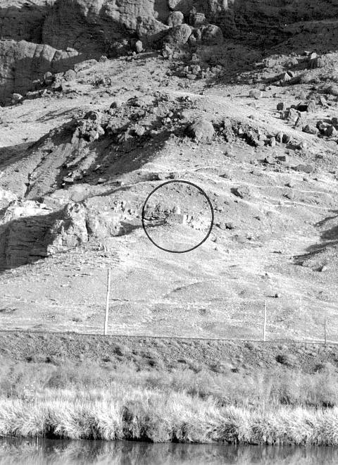
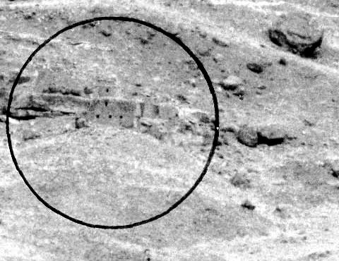
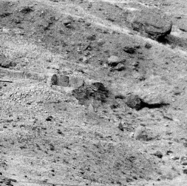
The church was surrounded on practically all sides by 16th and 17th century tombstones and partly broken khatchkars. Another cemetery was located on the mountain slope south of the church, which had a number of finely carved khatchkars and ram-shaped tombstones.
The Pombloz church was completely demolished in December 2002 (the aftermath was documented by photographs taken from the Iranian side of the border). The khatchkars and other gravestones formerly located on the slope below the church have also been entirely removed as observed by Steven Sim.
St. Astvadsadsin (Mother of God) Church
The current status of the St. Astvadsadsin Church is unknown, the description below is based on its condition in 1990.This church is located close to the rampart surrounding the town and was built on a high hill-like rock in the eastern part of the city. It has a rectangular floor plan, a vaulted roof, and an eastern apse with two small vestries. The church’s northern and eastern walls, built mostly of rough stone, are laid out on natural rocks. The interior was plastered.
The initial structure was built in the 12th or 13th century, and was probably restored at the end of the 15th century. Khatchkars in memory of Shak, Minas, Kheran and other Jughaites are located in the interior of the church, in the masonry of the vestries, and the raised chancel. Those on the western and southwestern ends of the church have since been removed.
St. Astvadsadsin is surrounded by a rather high secure wall making it look like a small fortress. A cemetery located southwest of the church on a nearby slope has 60 khatchkars and other tombstones which are either broken or partially buried. They date from the 16th and 17th century and have inscriptions which contain interesting information on the past history of Jugha.
*This page is excerpted from “The Medieval City of